Site location
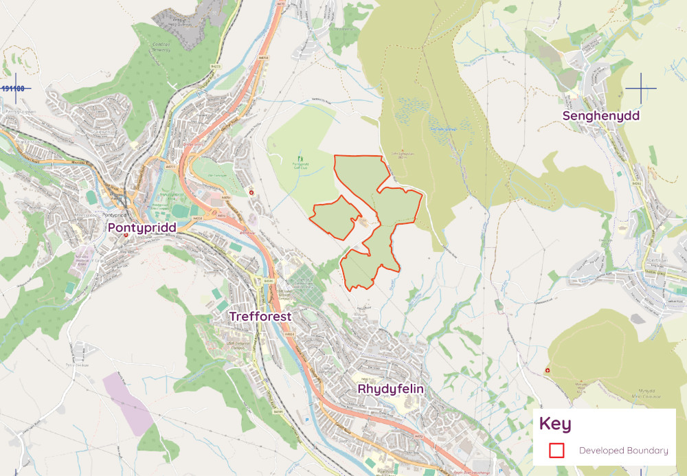
Gyn Taff Solar Farm would be located approximately 2 km to the east of Pontypridd Town centre.
The scheme extends to approximately 71 hectares of grade 4 agricultural land on the southern slopes of Eglwysilan Common, to the southeast of Pontypridd Golf Club.
The proposed site is situated within the wards of Rhydfelin Central, Trallwng and Treforest, in Rhondda Cynon Taf.
About the proposal
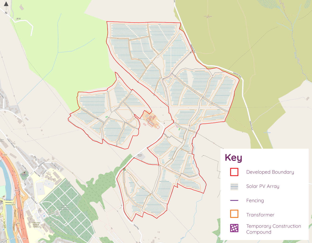
The proposal for the 39.9 Megawatt peak (MWp) solar farm includes the construction of a ground-mounted solar photovoltaic farm, associated access tracks, underground cabling, perimeter fencing with CCTV cameras and access gates, temporary construction compounds and all ancillary grid infrastructure and associated landscaping works.
The solar panels will be fixed tilt, bi-facial, ground mounted arrays. They will be up to 3m high and will be attached to a frame which is drilled into the ground to a maximum depth of 1-2 metres. This will cause minimal ground disturbance and reduce potential impacts on unknown sub-surface archaeology.
The design includes the provision of secure deer fencing running around the perimeter of the Proposed Solar Farm and set back 5m from existing field boundaries. The fence will be 2m in height with a 0.1m gap at the bottom allowing access for smaller mammals.
All on-site cabling will be located underground.
The panels will have a non-reflective surface, which will increase the proportion of solar radiation absorbed, removing the risk of unwanted reflection and glare.
The panels will convert the energy from sunlight into electricity. This would be a temporary use of farmland that is easily reversed at the end of its operational life.

Proposal updates
We are grateful for all the feedback received during our informal consultation during the summer 2024. This feedback has played a crucial role in shaping the evolution of the project.
Based on that feedback, further site investigations and surveys have been undertaken, and we have made changes to the project, as follows:
- Significantly reduced the overall site area from 101 hectares to 71 hectares.
- Removed specific land parcels where constraints such as biodiversity, flood risk, or landscape sensitivity were identified.
- Refined the position of infrastructure to minimise potential visual and environmental impacts.
- Proposed additional landscape and ecological enhancements to integrate the development more effectively within the surroundings.
These design changes reflect our commitment to delivering a well-balanced and sustainable renewable energy scheme that maximises clean energy generation while respecting the site’s environmental and community context.
We are committed to engaging with local stakeholders and are dedicated to ensuring that the final design continues to align with best practices and local considerations. We are now holding our statutory consultation, prior to submitting the Development of National Significance planning application to Planning and Environment Decisions Wales.

Grid connections
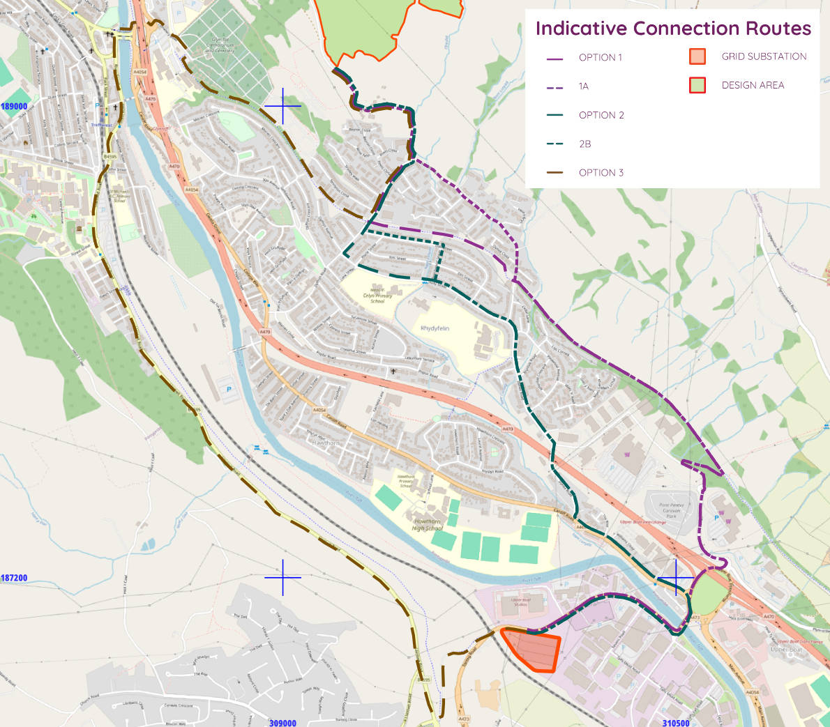
The site is ideally located for access to the local electricity grid network, being approximately 4.8 km from the nearest substation at Upper Boat, Treforest.
Electricity generated will enter the National Grid transmission network and be transported across Wales.

Environmental considerations
Surveys have been undertaken on a range of considerations, including ecology, landscape and visual impact, heritage and archaeology and noise to inform the final design of the solar farm.
Our studies have been conducted to ensure we identify any potential impacts and put in place appropriate mitigation measures for the project.
Landscape and visual impact
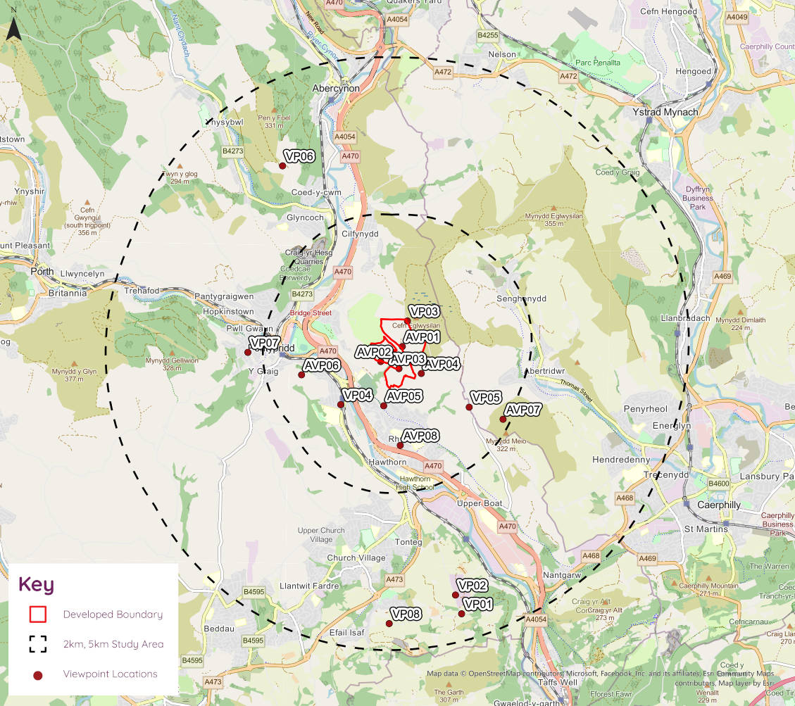
A Landscape and Visual Impact Assessment (LVIA) supporting the draft planning application has undertaken a detailed assessment of key viewpoints around the site.
During our informal consultation, stakeholders identified specific areas with more exposed views of the development site. We have undertaken additional landscape photography and photomontages to inform the necessary visual studies allowing the design to be refined to ensure that the solar farm sits more harmoniously within the surrounding environment.
The Proposed Development has been sensitively designed to integrate with the landscape and existing vegetation and field patterns. The solar panels have been located away from residential properties, ancient woodland, woodland and hedgerows, Public Rights of Way, and watercourses.
In addition, the enhancement of boundary treatments and carefully considered screening and planting strategies using native tree and hedgerow species are proposed to soften views of the Proposed Development.

Hydrology
A series of studies have been undertaken of the site in order to provide a detailed understanding of the current water environment and ground conditions. This included desk-based assessments and several phases of fieldwork.
The comprehensive Flood Risk and Drainage Impact Assessment (FRADIA) supporting the draft planning application has evaluated potential flood risk and surface water management requirements. Based on this assessment, the Proposed Development incorporates sustainable drainage solutions (SuDS), such as swales, attenuation basins, and vegetated buffer zones, to effectively manage surface water runoff and reduce downstream flood risk.
To further safeguard local watercourses, the proposed development will implement stringent pollution prevention and mitigation strategies such as designated buffer zones around water bodies to maintain natural filtration processes and protect aquatic habitats.
We are committed to delivering a responsible and environmentally sensitive renewable energy scheme that safeguards local water resources while contributing to the transition to clean energy.
Access, traffic and transport
The main site access point being considered during construction and operational is currently through Bryntail Farm via Bryntail Lane.
We are committed to carefully managing traffic and minimising disruption during the construction and operation of the solar farm.
Construction phase
If consented, construction is expected to take 12 months. The construction traffic is currently estimated to be in the region of approximately 20 HGV movements a day.
A Construction Traffic & Management Plan (CTMP) will be in place to ensure all vehicle movements are well-planned and controlled. During construction, traffic will be managed through:
- Agreed access routes – Working with local authorities, particularly Rhondda Cynon Taff County Borough Council, to avoid sensitive areas and reduce the impact on local roads.
- Controlled hours – No construction traffic during peak commuting times or school drop-off/pick-up period.
- Traffic calming measures – Including passing bays where needed to ensure safe vehicle movements on narrow rural roads.
Operational phase
Once operational, the solar farm will generate minimal traffic with only between 15 and 20 vehicle movements a year for maintenance visits. The site will have designated storage areas for:
- Temporary storage of materials during construction.
- Spare parts and essential maintenance equipment.
- A base for any necessary repairs over the lifespan of the solar farm.
Minimising local impact
To minimise local disruption, we will:
- Implement a structured delivery schedule to prevent congestion.
- Use a designated site entrance and exit strategy for safe and efficient access.
- Maintain regular communication with the local community about construction timelines and any temporary traffic measures.
These measures will ensure that the solar farm is developed and maintained with minimal impact on local roads, communities, and the surrounding environment.
Glint and Glare
A Glint and Glare Assessment supporting the draft planning application has undertaken a thorough analysis of any potential reflective effects from the proposed solar panels.
It is important to highlight that modern solar panel technology has been specifically designed to minimise glint and glare. The photovoltaic (PV) panels proposed will be coated with anti-reflective materials that significantly reduce surface reflection, and their primary function is to absorb sunlight rather than reflect it, ensuring maximum energy efficiency. It is therefore considered the level of reflected light from solar panels is considerably lower than from common surfaces such as water, glass windows, or car windscreens.
Noise
Solar panels operate silently, with the only potential noise coming from inverter stations, which are essential for converting electricity. Modern inverters produce low noise levels during the day and are inactive at night. The proposed development has ensured these are carefully positioned to ensure minimal disturbance to the community.
A Noise Impact Assessment (NIA) supporting the draft planning application has been undertaken. The NIA confirms compliance with acceptable noise limits.
Ecology
The Proposed Development does not lie within or adjacent to any statutory environmental designated sites. The nearest designated sites are Craig-Yr-Hesg Local Nature Reserve (woodland), located approximately 1.5 km to the northwest and Nant Gelliwion Woodland SSSI, located just under 3 km to the west.
Various ecological surveys have been undertaken including wintering and breeding birds, Great Crested Newts, bats, badgers, otters, water voles, amphibians and reptiles. Our surveys show no significant impacts are anticipated for any species or habitats on the site.
The project will deliver net benefit for biodiversity over its lifetime by creating new habitats offering food and shelter to wildlife, including priority species and breeding birds.
Cultural Heritage
The site has been extensively surveyed by the project team and a geophysical survey has been undertaken to assess any potential archaeological features within the site.
A Cultural Heritage Impact Assessment (CHIA) has been undertaken to evaluate and assess the potential effects of the solar farm on both known and undiscovered heritage assets. Heritage assets and recorded archaeological sites identified within the relevant study areas of 5km and 1km are summarised below. Within 5km of the Proposed Development Site there are a total of:
- 21 Scheduled Monuments;
- One Historic Park and Garden;
- One Historic Landscape;
- No Registered Battlefields;
- No World Heritage Sites;
- Three Grade I Listed Buildings;
- 22 Grade II* Listed Buildings;
- 123 Grade II Listed Buildings; and
- Nine Conservation Areas.
The findings of the assessment have helped guide mitigation measures, such as sensitive site design and screening, to ensure the solar farm integrates respectfully with the historical character of the area while supporting the transition to renewable energy.
During construction, we will work closely with heritage experts and local authorities appoint to closely monitor construction activities and ensure that in the unlikely event that any previously unknown heritage assets are discovered, these are recorded and protected on site during construction.
Public rights of way (PRoW)
Public Rights of Way (PRoW) will not be affected by the Proposed Development, including during the construction phase. Three are PRoWs running across the site and these will be maintained and suitably buffered. These will remain open and accessible to the public during construction.
There is no new PRoW planned for the scheme.
Project timeline
We have undertaking site surveys and environmental assessments to inform the preparation of a planning application and will be submitted an Environmental Impact Assessment (EIA) Scoping Direction request to PEDW.
We will proactively consult with the local community on the developing design before the submission of the planning application.
We want to ensure the community are given all the available information on the proposal and are given every opportunity ask questions and input provide their thoughts to maximise the benefit for the local area and the people that live there.
Follow our journey to decarbonisation
2021 – 2023
- Site selection
- Site surveys
- Environmental assessments
- Landowners’ agreement signed.
Spring 2024
- Early engagement with stakeholders
- Feasibility studies
Summer 2024
- Informal consultation
Spring 2025
- Statutory Consultation on detailed proposals
- Application submitted to PEDW
- PEDW Consultation on the DNS Application
Winter 2025
- Decision on the DNS Application
Summer 2026
- Construction begins – this is expected to take approximately 12 months
October 2027
- Solar farm becomes operational